
Standing tall
By the side of the road
I fell in love
With a beautiful highway
This used to be real estate
Now, it’s only fields and trees
Where, where is the town
Now, it’s nothing but flowers
The highways and cars
Were sacrificed for agriculture
I thought that we’d start over
But I guess I was wrong
“(Nothing But) Flowers,” Naked (1988), David Byrne, Talking Heads
The Wild
Climate Crisis in the Expanded Field (Greg Kochanowski)
One of the unusual things about Los Angeles is its proximity to wilderness. Not wilderness in its metaphorical sense, but actual wild-ness — places primarily uninhabited by human culture. Sometimes mythologized and exaggerated through media for dramatic effect, earthquakes, fires, floods, mudslides, droughts, sharks, mountain lions, etc. are rooted into the larger narrative and identity of the city. These various expressions of wildness coexist in stark juxtaposition to each other, illuminating the rich ecological and cultural diversity that make up this vast territory. The proximity of the urban fabric to these untamed environments is real and has significant impact on Los Angeles and the way we understand its overall ecological conditions, in general, as well as the future evolution of its urban fabric, in particular.
The most enduring of these expressions, and the one that is personally most appealing, is the city’s relationship to the natural environment. It is a city continually shaped and reshaped through the engineering of its landscape, aimed at both managing resources, i.e. extraction and transportation, on the one hand, and encourage real estate speculation and human occupation, on the other. The shaping of these wild spaces, including the hillsides of the Santa Monica and San Gabriel Mountains, the extreme environments of Death Valley and Mojave Desert, as well as the fluctuating coast of the Pacific Ocean, coupled with L.A.’s urban, political, and economic framework, contribute to the perception of Los Angeles’ impermanence and ad-hoc nature.
The continuous growth of the city creates an inherent conflict between the existing natural systems and the shifting cultural settlement patterns of an expanding population. The Wildland-Urban Interface (WUI) (1) is the territory of this conflict with the most challenging concerns being fire and debris flows. Little attention has been given to arid climates and the specific effects that the climate crisis has on these environments and communities. To better understand the future of Los Angeles, we must gain a greater understanding of these exurban environments and their effect on our ability to create fire-adapted landscapes, resilient infrastructure, and planning methodologies that both protect and enhance the lives of people and property. Over the past few decades Los Angeles has experienced an expanding of its fire season by as much as 2 – 3 months which threatens these wildland environments with more extreme temperatures, wide fluctuations in rainfall levels, and habitat degradation. As evidenced in the Woolsey, Thomas, and Paradise fires of the past two years, California, in general, and Los Angeles, in particular, is experiencing these changes on a more frequently recurring basis which, when followed by an increasingly active rainy season, exacerbates debris flows and mudslides within mountain environments.

Woolsey Fire, November 2018, Malibu, CA
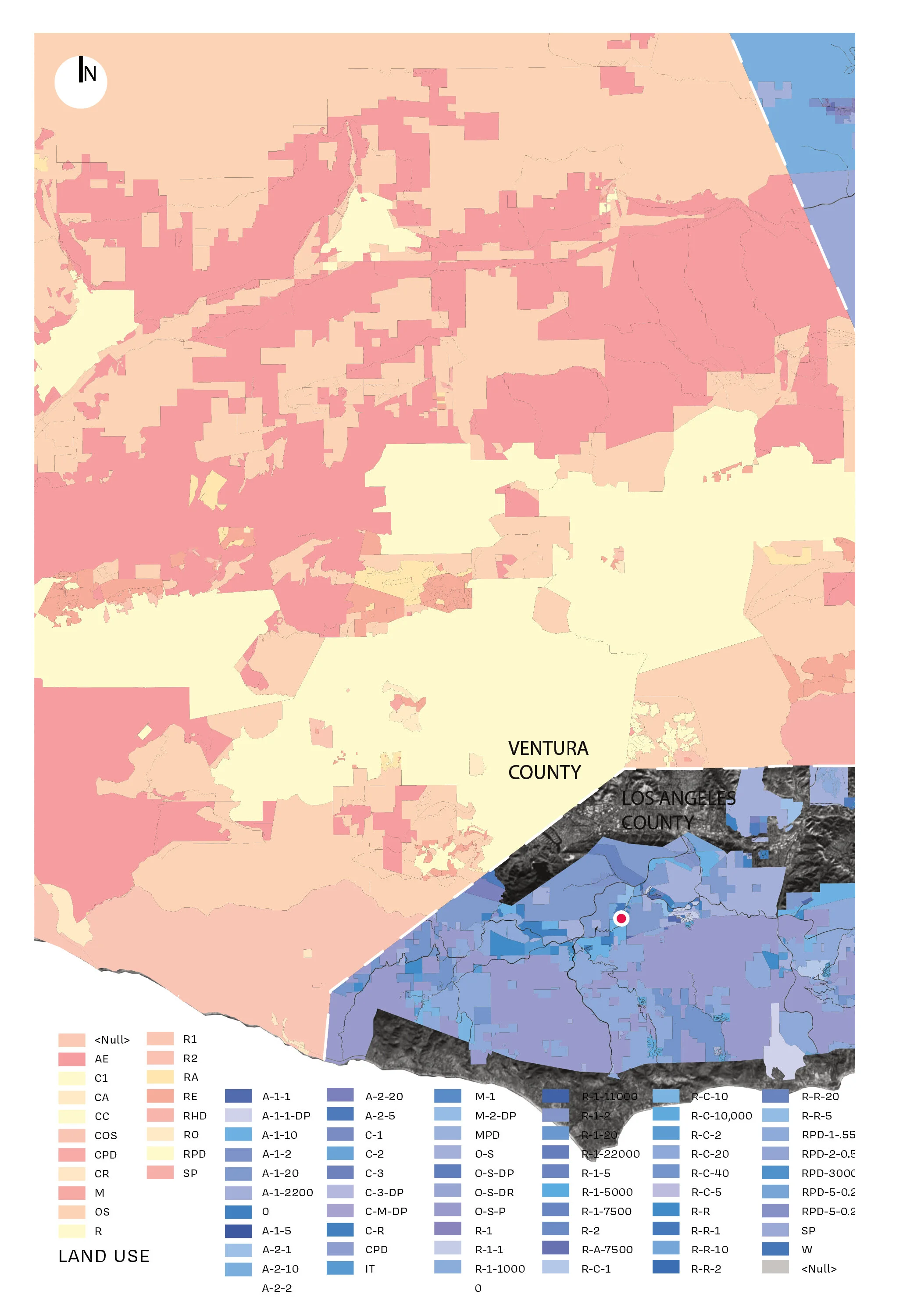
For large metropolitan areas such as Los Angeles, development within the wildland-urban interface reveals that the conflict between patterns of economic development subsidies and land use planning initiatives has substantially contributed to the extension of the urban fabric into these liminal territories of the periphery. In other words, urban development subsidies reinforce the reduction of economic activity across the city in a way that concentrates poverty at the urban core while incentivizing risk through a rapid consumption of land at the urban fringe. In post-war America, the dynamic of sprawl grew out of these two conflicting policy territories, indicating that the left hand of State law is fighting the right hand of State government. In short, subsidies (because they are largely untargeted geographically) are undermining good planning, resulting in a model of “self-organized” development that occurs without proper consideration or understanding of these fire adapted landscapes. Sprawl is a complicated issue that has many other causes, including redlining (racial discrimination in home lending), perceptions of crime in inner-city environments, brownfields or contaminated land that makes redevelopment of some abandoned sites more difficult, transportation policies that favor highways over transit, exclusionary zoning and NIMBY-ism that blocks densification of residential units, and federal capital-gains rules that, for decades, encouraged people to buy and develop ever-larger homes, all of which must be addressed to ensure the development of healthy and vibrant urban environments.
“In Wildness is the Preservation of the world”
— Henry David Thoreau
Typically seen as “empty” for the purposes of development, the wildland territories surrounding Los Angeles are in fact dynamic ecosystems operating at the same scale and complexity as the vast metropolis next to which they reside. Mountains, thick with vegetal, biological, and geologic diversity, endlessly transform through cycles of extreme drought, fire, and flood, into territories subjected to extreme fluvial forces that surge through developments, aggressively reestablishing the natural dynamics of the hillsides while reclaiming areas of the city fabric. Fires and debris flows have existed within the mountains of Los Angeles for millennia. The San Gabriel Mountains, for example, are the most dynamically changing mountainous terrain in the continental United States, continuously eroding and shedding sediment which is managed through an elaborate series of infrastructures, policies, and practices by the Los Angeles Flood Control District. Fires, too, seen as catastrophic anomalies, are in fact endemic to these lands, managed and experienced by the Native American Chumash tribes over hundreds of years. They understood their relationship to the land as a form of stewardship. Contrary to this the United States, following the Great Fire of 1910, has enforced the current policy of fire suppression. Fire is equated with destruction. The “Smokey the Bear” campaign promoted firefighting, placing the focus on prevention through investment in a military level of infrastructure and technology. These environments are natural fire ecosystems which, due to expanded development patterns, are exacerbated by human occupation. In fact, over the past 100 years, 98% of all fires in Southern California have been man-made. It is important to note that holistic stewardship and land management practices have been replaced in favor of singular policies and infrastructural investments that did not account for the natural processes of these landscapes. With our rapidly changing climate, these policies are central to reframing the way people can (and should) relate to these fire-adapted landscapes.

Blackfeet Burning Crow Buffalo Range, Charles Marion Russell, 1905
The Campfire in Paradise, CA began on November 8, 2018 and was followed by the Woolsey Fire in Los Angeles on February 6, 2019. (6) Uncannily, one year later, the fires in Australia, which began in November 2019, presented a formidable atrocity marked by the loss of property, human life, and the unimaginable devastation of wildlife, unparalleled to anything seen in the United States. The magnitude of the destruction was almost incomprehensible; at last count, it was estimated that a billion animals perished in the fires. Undoubtedly, such destruction and mass extinction of animal species has not been seen since the dropping of the atomic bomb in Nagasaki. Such cataclysmic events highlight the interconnectedness of the human species to the rest of the natural world, and the way we are causing, ultimately, our own extinction.
“Wildness is not the preservation of the world,
it is the world”
— Gary Snyder, The Practice of the Wild
The devastating effects of fires and debris flows cost more money globally, through physical and economic loss and reconstruction, than all other forms of disasters combined. (7) The Woolsey Fire in Malibu and Agoura Hills is estimated to have cost in excess of $19 billion, the most spent on any wildfire in the state’s history. Similarly, the Los Angeles County Flood Control District is projected to spend an estimated $279 million over the next 20 years managing existing debris practices and infrastructure. These catchment basins are constructed to prevent the even more significant costs of catastrophic mudslides such as those in January 2018 that followed the Thomas Fire (2017), the largest wildfire in modern California history at the time, which devastated large areas of Ventura and Santa Barbara Counties, destroying large parts of Montecito, and costing in excess of $1 billion, not to mention the loss of life. In the wake of the Woolsey Fire, a staggering 300,000 tons of debris have been removed, with about 132,000 tons of debris remaining, by conservative estimates, from the 1,700 homes destroyed and the hundreds of acres that were burned. With the projected increase in the frequency of fire and debris flow events over the coming years, these numbers are only expected to increase. Within this evolving context, and its resulting devastation, in the form of wildfires and debris flows of increased magnitude and frequency, we are forced to imagine new forms of land management practices and infrastructures. Specifically, this means a new understanding of the relationship between communities and fire ecosystems, one in which members participate in the management and stewardship of their environments.
“If Los Angeles hangs on long enough, it will cart the mountains entirely away....”
— John McPhee, The Control of Nature
In Building Resilience: Social Capital in Post-Disaster Recovery (2012), Daniel Aldrich argues that true resiliency is established within localized social networks that allow communities to recover following a disaster. He notes, interestingly, that the term disaster in sociological contexts refers to the failure of social systems, or to “collective events that at least temporarily, and often for years afterward – suspend normal daily life routines owing to widespread damage.” He argues that the role of social capital, more than economic resources, government assistance, or degrees of damage, contributes further to the success of a community to successfully facilitate reconstruction and increase its rate of recovery. Following Katrina, for example, the community of Village de l’Est in New Orleans East centered around the Mary Queen of Vietnam church, recovered within 2 years, rebuilding most of its homes and recovering a majority of shops, even though their income was lower than the state and national averages and they received little governmental assistance after the flooding. In contrast, the Lower Ninth Ward (whose poverty rates were equal to that of Village de l’Est) had only 30% of its residents return and has yet to still to recover.
Following a crisis, as members of a community become physically dislocated from each other, sometimes fleeing 30-60 miles away, or further, for an extended amount of time, the most important commodity becomes the ability to directly and immediately communicate information. The proliferation of technology and social media over the past 10 years has significantly supplemented the ability of communities to circulate and employ information that was unheard of 20 years ago, greatly advancing its ability to formulate a cohesive response following a disaster. During these times texting, social media, and email, keeps people informed and assists in organizing town hall meetings, sessions with federal agencies, and rebuilding workshops. This dynamic communication has also been discussed in many venues around the subject of disaster relief, political protests, and the like. The design community, however, is slow to understand how this can be leveraged. For example, what is the role of design in the exchange of information? How can we best utilize the skillsets we bring to the table as design professionals?
The role of design within the built environment is about forming relationships. It is through the manipulation of social space that we foster new ways of relating to each other and, in that way, the model of the single-family home has created a model of society based on individual ownership. This originated primarily in the 1950’s through the model of suburbanization, freeways, and increased car ownership. Consequently this, along with the “American Pioneer Spirit,” resulted in forging relationships based on individual ownership as opposed to collective cooperation. We all live this way it is ingrained into our psyche. Too often we live in enclaves, both physical and digital, sometimes gated, sometimes not, miniature bubbles within bubbles where we can construct our own reality. But not all societies live this way. In fact, most of the world does not.. Multi-generational housing is seen as a novel idea in America, but in other countries (primarily Asia) it has been the model of living for centuries.
Understandings of resilience in the natural sciences emphasize the capacity of living systems to adapt to disturbance. In architecture, resilience has become coupled with the desire to rebuild, in part through its association with disaster events. In contrast to scientific understandings of resilience as a measure of the adaptive capacity of an ecosystem over time and its ability to return to a state of eqilibrium,
Within Wildland environments, the controversy of the individual versus the community is very thick with potential on the conflict between property rights, investment in public protective services, and safety, tied to many of the issues raised prior. Central to this conflict is the notion of responsibility. The general public is averse to subsidizing those who make risky decisions about where to live. Many believe that the general public should not have to pay the cost of the enormous fire suppression infrastructure and manpower needed to fight these ever-increasing and all-powerful fires. These issues get to the heart of rethinking the political framework of the wildland-urban interface, namely, forming an argument around personal responsibility that is not punitive, but rather catalyst for change. How can “personal responsibility” foster, and translate into, a new understanding of collective land stewardship? How can new models of insurance, such as parametric insurance,8 facilitate and promote, these new stewardship models in such a way that allows for both personal responsibility while also reinforcing community? How does this transform our understanding of living in these environments, and how can this carry forward into other environmental conditions impacted (or soon to be impacted) by climate change?
These latter questions, I think, hold the key to developing a more resilient future in the face of the impacts of the climate crisis. It is beyond question that we need large-scale, global, and multi-national alliances to drastically cut levels of CO2 but we also need to ensure that communities and jurisdictions build resilient physical, social, and economic networks capable of adapting to localized contexts and environments.
Los Angeles is a city born out of a relationship between the wildness of its natural environment and the extensive investment in infrastructure that supports our efforts to tame, what has become, this wild urban place. From extracting the natural resources essential to the functioning of the city, to establishing a transportation network to carry people and goods across its wide terrain, Los Angeles has long been dependent upon massive public works programs to overcome the environmental and geographical challenges of its locale. As the population has exponentially grown over the past 40 years, these systems have been unable to accommodate the increased population, forcing further tentacles to spread across the Western United States. California imports more electricity than any other state, from primarily wind and hydroelectric power in the Pacific Northwest to nuclear, coal, and natural gas-fired production in the deserts of the Southwest. Half of Los Angeles’ water, too, is siphoned from the Colorado River outside the boundary of California. These umbilical cords are also reflected in the freeway systems that extend the metropolis out into interface territories intersecting these corridors of water and power that are subject to the extreme, and ever-changing, effects of the climate crisis.
The goal of adaptation strategies is to establish a symbiosis between cultural, economic, biological and environmental infrastructures and systems.
The most impactful form of infrastructure effecting the WUI is electricity. Los Angeles brings power from huge distances outside the city, through areas that are highly susceptible to fire. As such, the planning (or re-planning) of our power infrastructure needs to be rethought. Currently this is managed through only two private entities in California: Pacific Gas and Electric Company (PG&E) and Southern California Edison, both of whose infrastructural failures (just in the past 2 years) were responsible for the largest fires in the history of California. Los Angeles imports massive resources from outside its borders, supporting an urban environment that would not otherwise be able to exist at the scale that it currently does. We live in opposition to our environment, bringing in water and power to support this great metropolis and, as such, have created a situation that puts the city and its residents at great risk during a disaster. This was made evident, recently, with PG&E’s decision to have extended mandatory blackouts during high wind events, which disproportionally impacted the poor and elderly. What we need is a radical rethinking of our utility system, a new approach that would switch from a strict hierarchy organized around a single source, to that of a distributed network of autonomous microgrids that operate at a local level in response to climatic and environmental shifts, based on a model of sustainability and efficiency.

Powerlines and Wildfire, Sylmar, CA (Irfan Khan / Los Angeles Times)
This new understanding of infrastructure should extend to public space as well to consider its role in the resilient planning of fire ecosystems. During the Woolsey Fire, Zuma Beach was used as a place of refuge and an evacuation point for people and animals (farm, domestic, and exotic) as well as a staging area for firefighters and assistance organizations. While the original design of the beach did not anticipate such an event, nonetheless it was able to accommodate the needs and demands of the disaster. As we begin to envision new open spaces within the wildland-urban interface, we should understand them as part of a multivalent set of unanticipated and emerging programmatic needs.
Through a deeper understanding of these wildland territories, and the effects of human occupation within them, we can develop urban tactics and strategies that begin to imagine a future Los Angeles that acknowledges and operates within the trajectory of an ever-changing climate. The idea of wilderness connects us with an unknown potential, a mystery that is both comprehensible and unfathomable, comforting and dangerous, present in our everyday experiences and imaginations yet remote. The wilderness that is Los Angeles has given birth to an urban condition of conflicting, yet occasionally harmonious, relationships among its people, economies, vegetation, geology, biology, infrastructure, and the larger environment.

Zuma Beach, Woolsey Fire 2018. (Photo: Wally Skalij/Los Angeles Times via Getty Images.)
As we imagine the future of Los Angeles, we should understand that we are living in a future-present9. In other words, irrespective of policy changes, the next ten years or so will bring about changes in the climate based on previous consumption patterns of emissions of carbon dioxide. Much like shutting off a boat engine that continues to drift towards the dock, the climate continues to warm long after the effects of policies are measured or implemented. The issue, then, is that we are not slowing down the “engine” of carbon emissions, and so the projection of the manifestation of change continues to increase. Fires, floods and debris flows will continue to increase in quantity and magnitude. The question, then, is how to operate within such an environment. A key to this future-future (so to speak) is our ability to coexist with the wilderness. This would involve fusing cultural, environmental, and biological systems into a synergistic network that enhances the habitat for people, fauna, flora, and all the creatures that populate it, as well as the dynamic landscapes that have existed for millennia, to create a new sustainable model for living in the Wild. Planning, too, has a significant role in this. In fact, the absence of the voice of the design community in these discussions has allowed the culture of fire suppression to persist. Design is the way we envision new futures, and it is this role that is desperately needed as we look for solutions to our ever-changing climate.
“Landslides and other ‘ground failures’ cost more lives and money each year than all other disasters combined, and their incidence appears to be rising. Nevertheless, the government devotes few resources to their study - and the foolhardy continue to build and live in places likely to be consumed one day by avalanches of mud.”
- Brenda Bell, The Atlantic Monthly (Jan. 1999)

In this photo provided by Santa Barbara County fire department, Kerry Mann navigates the large boulders and mudflow that destroyed the home of her friend in Montecito, California. Photograph: Xinhua / Barcroft Images
Much has been said about resiliency but we should try to define that term a bit more specifically. “Resilient” does not equate with “resistant.” Rather, resilient refers to the capacity of a system (or people) to maintain the same general structure, composition, and feedback processes following disturbances and other shocks. In social systems it is the ability to bounce back after a disturbance or a disaster. Therefore, disasters are not prevented but managed. In other words, if we choose to continue developing within these wildland-urban interface territories and ecosystems, we must shift our understanding of what it means to coexist with these complex ecosystems. New thinking regarding this sensibility moves beyond the term “resilient” toward that of “adaptation”. Adaptive resilience changes a system’s fundamental characteristics in reaction to new or dynamic conditions. Transformational Resilience, then, takes that a step further by creating fundamentally new systems that require a profound shift in our relationship with ecological systems by embracing the dynamic and rapidly changing role of, in this case, wildfire and the role of fire in socio-ecological systems. In other words, this latter definition of Transformational Resilience, posits a paradigm shift in the way we relate, and respond, to the fire and debris prone landscapes of the wildland-urban interface. (10)
We, the design community, can support communities as they grapple with the uncertainty of the ever-increasing environmental challenges through education and design guidelines that can be initiated either prior to, or following, a disaster. By providing models of living and ways of building (organizational patterns, technologies, typologies) that attempt to mitigate the impact of these events, utilized in the rebuilding following a fire, we can begin to set in place ways of living with these environments, instead of in opposition to them. Planning has a significant role to play. When we consider the future planning of a community we should understand the site in a much broader context. For one, the effects of climate change do not prescribe to traditional boundaries so, as such, we should be thinking more broadly about what constitutes a site. That involves extending our understanding of infrastructure, habitat, and ecology that reach far beyond the traditional limits of project study.
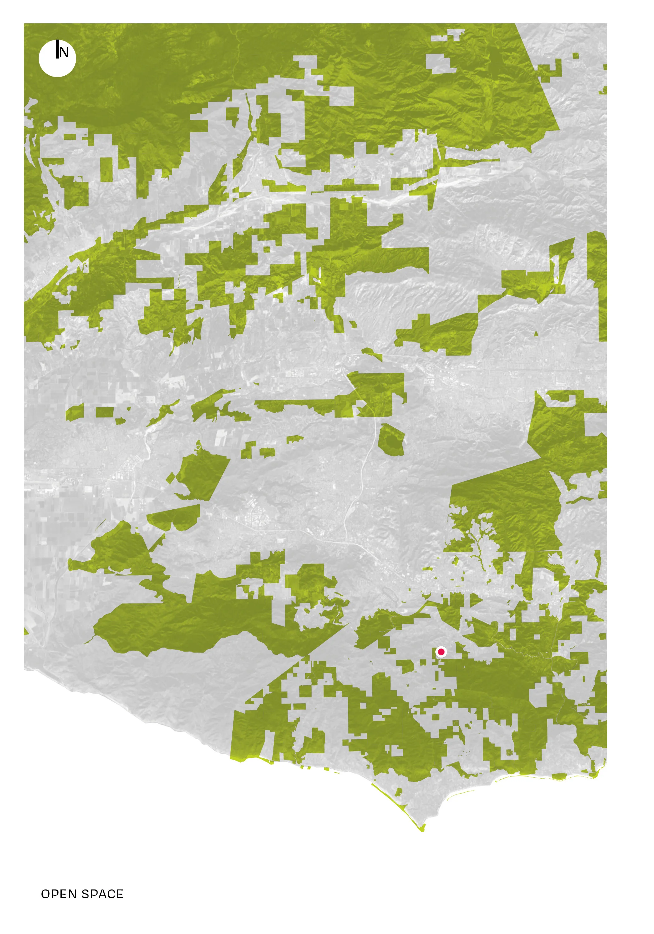
We at The Wild explore the urban periphery of Los Angeles, where the city meets the mountains, a landscape inherently vulnerable to wildfire and its secondary and tertiary effects, including flash floods and debris flows. We seek to document the policies that have incentivized growth at the exurban periphery and reveal the risks produced by the urbanization of the fire-adapted landscape. In so doing, we hope to show how urban planning and policy have failed to account for the risks inherent in Southern California’s unique landscape and highlights the hidden costs of exurban growth, by probing the mechanisms through which the vulnerability of the urban periphery can be reduced using landscape management protocols, open space visions, and inventive infrastructure that adequately account for the temporal cycles of wildfire and debris flow in the Los Angeles area.
Greg Kochanowski, Founder


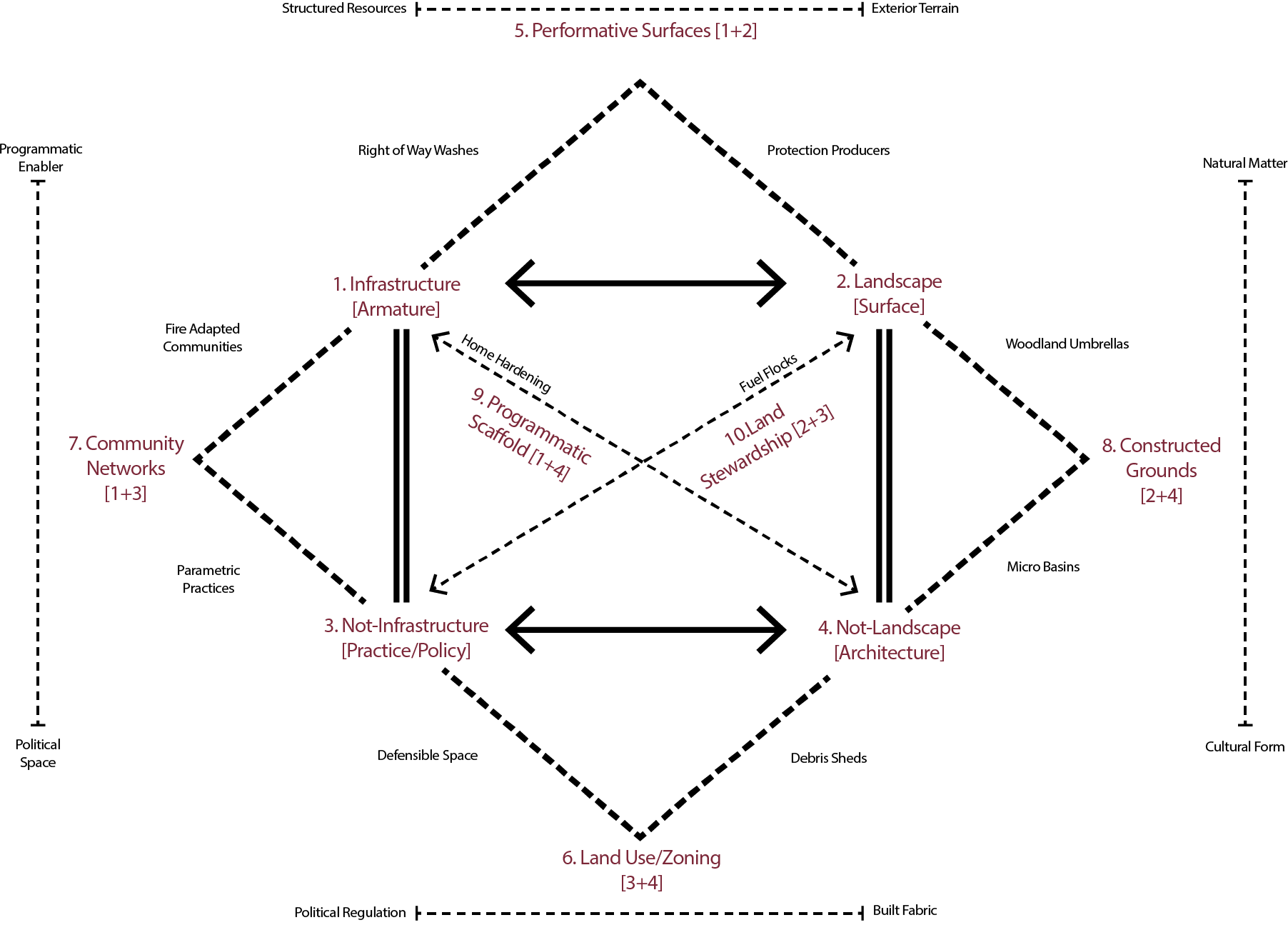
overlaps & combinations


Footnotes
01 The Wildland-Urban Interface (as well as Intermix or Interior) is a zone of transition between wildland (unoccupied land) and human development. Communities in the WUI are at risk of catastrophic wildfire and their presence disrupts the ecology. Interface WUI, or lands that contain at least one housing unit per 40 acres (16 ha) in which vegetation occupies less than 50% of terrestrial area (at least 2.4 km2). Structures in intermix WUI are interspersed with vegetation, whereas homes in interface WUI are adjacent to heavy vegetation. Volker Radeloff et al., “The Wildland-Urban Interface in the United States,” Ecological Applications vol. 15, issue 3: 799-805.
02 Forests, shrub lands, grasslands, and other vegetation communities that have not been significantly modified by agriculture or human development*. A more specific meaning for fire managers, used by the National Wildfire Coordinating Group (which coordinates programs of participating wildfire management agencies nationwide), refers to an area in which development is essentially non-existent (except for roads, railroads, power lines, and similar transportation facilities); structures, if any, are widely scattered. United States Department of Agriculture, “Wildfire, Wildlands, and People: Understanding and Preparing for Wildfire in the Wildland-Urban Interface,” General Technical Report RMRS-GTR-299 (January 2013), https://www.fs.fed.us/openspace/fote/reports/GTR-299.pdf
03 The Great Fire of 1910 (also commonly referred to as the Big Blowup, the Big Burn, or the Devil’s Broom fire) was a wildfire in the western United States that burned three million acres (4,700 sq. mi; 12,100 km2) in North Idaho and Western Montana, with extensions into Eastern Washington and Southeast British Columbia, in the summer of 1910. (Source: “Teddy Roosevelt and the Fire That Saved the Forests,” NPR (October 29, 2009), https://www.wbur.org/npr/114248029/story.php. See Timothy Egan, The Big Burn: Teddy Roosevelt and The Fire That Saved America (Boston: Houghton Mifflin Harcourt, 2009).
04 Source: https://smokeybear.com/en/smokeys-history/story-of-smokey
05 A fire adapted community, defined by the United States Forest Service, is “a knowledgeable and engaged community in which the awareness and actions of residents regarding infrastructure, buildings, landscaping, and the surrounding ecosystem lessens the need for extensive protection actions and enables the community to safely accept fire as a part of the surrounding landscape.” (Source: USDA Forest Service, Fire and Aviation. 2014.[what does this date refer to? Is it related to the plan: https://www.fs.usda.gov/sites/default/files/media_wysiwyg/usfs_aviation_strategic_plan_2014-2018_508_compliant.pdf) Fire Adapted Communities Learning Network, https://fireadaptednetwork.org/about/frequently-asked-questions/
06 The Camp Fire was the deadliest and most destructive wildfire in California history and the most expensive natural disaster in the world in 2018 in terms of insured losses. Named after Camp Creek Road, its place of origin, the fire started on November 8, 2018, in Northern California’s Butte County. https://en.wikipedia.org/wiki/Camp_Fire_(2018)
07 Research suggests that the total costs of a wildfire are typically 10 to 50 times its suppression costs. Given that the United States spends roughly $2.0 to $2.5 billion on wildfire suppression per year, we estimate that the total cost of U.S. wildfires is presently between $20 billion and $125 billion annually. Current analysis predicts future climate change-induced wildfires will cost the United States between $10 billion and $62.5 billion annually by 2050, with a middle estimate of $22.5 billion. This represents roughly 0.06 percent to 0.36 percent of projected U.S. GDP. Similar estimates for global climate change-induced wildfires imply potential damages of $50 to $300 billion annually in 2050, with a middle estimate of $100 billion. (Source: Peter Howard, Flammable Planet: Wildfires and the Social Cost of Carbon (2014). The Cost of Carbon Project is a joint project of the Environmental Defense Fund, the Institute for Policy Integrity, and the Natural Resource Defense Council), https://costofcarbon.org/files/Flammable_Planet__Wildfires_and_Social_Cost_of_Carbon.pdf
08 Parametric insurance is a type of insurance that does not indemnify the pure loss, but ex ante agrees to make a payment upon the occurrence of a triggering event. The triggering event is often a catastrophic natural event which may ordinarily precipitate a loss or a series of losses. (Source: https://en.wikipedia.org/wiki/Parametric_insurance). Recently, the Nature Conservancy has partnered with the government of the state of Quintana Roo, Mexico, to purchase a parametric insurance product that would offer up to $3.8 million to repair hurricane damage to the reef. This is the first time a natural resource vital to the economic and environmental success of a region has been insured.
09 Future present is a play on a tense. It says something will have happened. The future is present. Life gets so busy and focused on the immediate that it is much easier to live and act in the past continuous tense unable to change or shift out of old ways of doing, thinking, or being. It does take some kind of intervention, space, and intentionality to have a different kind of conversation.
10 David McWethy et al., “Rethinking Resilience to Wildfire,” Nature Sustainability, volume 2 (2019): 797–804.https://www.fs.fed.us/rm/pubs_journals/2019/rmrs_2019_mcwethy_d001.pdf
11 In 1938, a book entitled Sierra Nevada: The John Muir Trail arrived at the office of Harold L. Ickes, the United States Secretary of the Interior. It was filled with stunning images of California’s Kings River Canyon region captured by an aspiring photographer named Ansel Adams. When President Roosevelt was shown the book, he liked it so much he quickly appropriated it in advancing his efforts to establishment the National Park System. (Source: Ken Burns’ “The National Parks: America’s Best Idea”). Ansel Adams, Sierra Nevada: The John Muir Trail (Berkeley, California: The Archetype Press, 1938).
13 Fuel management programs support the strategic removal of grasses, shrubs, and trees to restore and maintain ecosystems and limit the negative impacts of wildfires. During a wildland fire all kinds of plant material can act as fuel, including grasses, shrubs, trees, dead leaves, and fallen pine needles. As these burnable materials pile up, so do the chances of catastrophic wildland fire. In the right conditions, excess fuel allows fires to burn hotter, larger, longer, and faster, making them more difficult and dangerous to manage. (Source: U.S. Department of the Interior: https://www.doi.gov/)
14 The California Department of Forestry and Fire Protection is the State of California’s agency responsible for fire protection in State Responsibility Areas of California totaling 31 million acres, as well as the administration of the state’s private and public forests.
15 California oak woodland is a plant community found throughout the California chaparral and woodlands ecoregion of California in the United States and northwestern Baja California in Mexico. Oak woodland is widespread at lower elevations in coastal California; in interior valleys of the Coast Ranges, Transverse Ranges and Peninsular Ranges; and in a ring around the California Central Valley grasslands. The dominant trees are oaks, interspersed with other broadleaf and coniferous trees, with an understory of grasses, herbs, geophytes, and California native plants. (Source: U.S. Forest Service, https://www.fs.usda.gov/).
16 Acorns were a staple food for the Native Americans. The acorns were used to make shawii (an acorn mush). Acorns were gathered in late fall, stored in granaries, dried, pounded, sifted, leached in special baskets to remove the, and boiled into thick mush. The bark was used to treat toothaches and a decoction of chipped bark was used as a wash for sores. The wood served as fuel for firing pottery. Native American cultures from Southern California also had multiple uses for the coast live oak. When hunting small mammals, hunters used the meat from the interior of acorns to bait their animal traps. The scent of the acorn meat could draw in a range of wild animals. (Source: UC San Diego, https://www.sandiego.edu/cas/biology/kumeyaay-garden/plants/coast-live-oak.php)
17 Coast live oak is exceptionally fire resistant, more so than other California oak species. Adaptations to fire include evergreen leaves, thick bark, and sprouting ability. Evergreen leaves allow coast live oak to allocate greater amounts of energy to recovery from fire than to replacing the entire crown annually. Evergreens are often better able to conserve nutrients than deciduous species and are favored in fire-prone environments. Coast live oak bark is the thickest among California oaks; it is mainly composed of live inner bark with little dead outer tissue. Oaks are more likely to be damaged by fall fire than earlier fires. Because of mortality among small-diameter trees, frequent fire limits coast live oak invasion of grasslands. Coast live oaks sprout from the main trunk and upper crown even after severe burning. When trees are top-killed, they sprout from the root crown. Vigorous sprouting is supported by food reserves stored in the extensive root system. Sprouting from the root crown often occurs during the first 2 months after top-kill, but some charred trees do not sprout for 2 to 3 years. Scorched trees retaining live vascular cambial tissue sprout from the bole and from scaffold and smaller surviving branches. A few scorched trees may produce root crown as well as epicormic sprouts. Pre-fire crown volume is generally recovered, or nearly so, in about 8 to 10 postfire years. (Source: U.S. Forest Service, https://www.fs.usda.gov/)
18 Evapotranspiration (ET) is the sum of evaporation and plant transpiration from the Earth’s land and ocean surface to the atmosphere. Evaporation accounts for the movement of water to the air from sources such as the soil, canopy interception, and waterbodies. Transpiration accounts for the movement of water within a plant and the subsequent loss of water as vapor through stomata in its leaves. Evapotranspiration is an important part of the water cycle. An element (such as a tree) that contributes to evapotranspiration can be called an evapotranspirator.
19 See Refugia Research Coalition, https://www.climaterefugia.org/
20 A spring box is a structure engineered to allow groundwater to be obtained from a natural spring. The spring box functions to protect the spring water from contamination, normally by surface runoff or contact with human and animals, and provides a point of collection and a place for sedimentation. In many instances it also acts as the principal water storage for the household water supply. Source: U.S. Forest Service and Wikipedia, https://en.wikipedia.org/wiki/Spring_box