
Transects
noun
/`transekt/
1. A straight line or narrow section through an object or natural feature or across the earth’s surface, along which observations are made or measurements taken.

Fire breaks, a gap cut through dense vegetation or forested regions that are susceptible to wildfires, interrupt the continuity of fuel. Forested areas usually contain vast networks of firebreaks both natural (rivers, lakes, canyons) or constructed (roads, highways, cleared zones) which assist firefighters during an event. Prescribed, or controlled, burning also helps to clear understory growth thus reducing the ability of flames to climb (ladder) to upper tree canopies. Native Americans utilized prescribed burns to manage the landscape and agricultural production, coexisting with the dynamics of the Western prairie landscapes. While helpful when trying to prevent fuel based wildfires, firebreaks are ineffective when combating wind driven fires. During extreme wind events, embers the size of soccer balls can travel upward of half a mile.

Following the Great Salem Fire of 1914 in Massachusetts, the United Stated government enforced a policy of fire suppression. The “Smokey the Bear” campaign, which began in the 1950s, promoted firefighting, placing the focus on prevention of fires rather than the proper management of the landscape. Ironically, when Theodore Roosevelt launched his campaign for the National Park System, between 1901 and 1909, celebrating the wildlands of the west through the photographs of Ansel Adams, it was managed landscapes that were photographed11. Forests effected by logging were presented as unbounded and uninhabited by man whereas it was just the opposite. These forests had been thinned over the years, preventing devastating wildfires from occurring. Once the policy of suppression supplanted these practices, these same forests became tinderboxes for future devastation.

The debris flows of the Thomas Fire of 2018 devastated the city of Montecito, CA. Although brought on by an unprecedented rainstorm, debris flows in this area were not only unprecedented, but historically repetitive. Much like the fire adapted landscapes of Malibu and other areas, these landscapes have seen debris flows for millennia. As fires move through the mountains above, they burn off slope stabilizing vegetation while chemically changing the composition of the soil. During a rain event, this soil is then washed off, catapulting it down the steep terrain where it builds up velocity and collects more and more debris (including boulders, cars, trees, etc.). The landscape is scarred by the trajectory of this debris over the years, which is also evidenced by the lack of indigenous oak trees through wide swaths of the landscape. These paths of debris flow alter development patterns over time, or sometimes go ignored altogether.

Within mountainous terrain, the issue of access and egress is critical. Most developments within mountainous terrain are served by substandard roads, too narrow for fire truck access or for two cars to pass each other. In addition, many of these roads are dead ends, without proper turnarounds. During emergency evacuations, these roads become clogged with traffic preventing residents from fleeing and putting them at risk in the path of fast-moving wind driven fires. Malibu, for example, is served primarily by the Pacific Coast Highway giving residents two directions, north and south, for evacuation. During the Woolsey Fire of 2018, the northbound Pacific Coast Highway was shut down, trapping people in gridlock while fires rolled through the city. Consequently, open spaces such as the beach became evacuation zones and areas of refuge. These public zones operate in a multivalent manner, supporting communities with spaces for recreation and gathering during ordinary times while capable of serving as evacuation centers in times of crisis. Critical to rethinking these interface zones is the ability to reimagine these types of infrastructure and the manner in which it can accommodate various unexpected programs and perform at multiple levels. Although able to function, obviously the beach was not designed in anticipation of such an event. When envisioning new open spaces in the wildland-urban interface, it is critical to consider their programmatic potentials as part of a set of large-scale operations that include disaster and emergency response.

Named after Southern California’s Santa Ana Canyon, the Santa Ana Winds are a blustery, dry, and warm (often hot) wind that blows out of the desert. A popular misconception is that the winds are hot owing to their desert origin. However, the Santa Anas develop when the desert is cold, hence being most common during the cooler seasons of October through March. High pressure builds over the Great Basin (e.g., Nevada) and the cold air there begins to sink. This air is forced downslope where it compresses and warms at a rate of approximately 29 degrees per mile of descent. The air picks up speed as it is channeled through passes and canyons, raising its temperature, and lowering its humidity levels, sometimes approaching zero. Santa Anas can cause a great deal of damage. The fast, hot winds cause vegetation to dry out, increasing the danger of wildfire. Once the fires start, the winds fan the flames and hasten their spread by ‘jumping’ embers across the landscape. Therefore, wind driven ember fires are the primary form of wildfire in Southern California.
An ember is a small, glowing piece of superheated wood, coal or other material that remains after (or sometimes precedes) a fire. Embers can glow as hot as the fire from which they arise and are light enough to be carried by the wind for long distances without being extinguished. They are the primary reason properties go up in flames whenever a wildfire is nearby. An event known as an “ember attack” commonly occurs during wildfires. It causes burning parts of branches or leaves to become airborne and fly off as a large cluster of glowing embers, sometimes traveling as far as a half mile. Not only can these embers be carried to the outside of your property, but they can contact the inside by floating through vents, windows, or crawl spaces. As a result, they can ignite any flammable objects inside the home, including the house itself. But aside from an ember attack, even just one ember is enough to initiate a structure fire.
SPECULATIONS

Protection Producers
Urban organic waste is used to create compost which helps to mend arid soil for agriculture. This process also increases its capacity to absorb and retain water, which greatly aids the effectiveness of the fire breaks. Strips of agriculture, falling along east/west transit corridors as well as vacant and publicly owned lands, create vegetated fuel breaks. The scrub matrix in these areas is transferred into a sustainable agriculture that provides habitat connectivity and organic soil matter while reducing wildfire fuel load. This nuanced approach would promote restorative practices within fire adapted ecosystems to prevent the impact of habitat fragmentation. Additionally, the agriculture would be diversified and ecologically integrated as much as possible, utilizing grazing as agriculture, fruit trees, orchards, and the like.
These areas would also reduce heat island effects and aid in stormwater capture, promote soil health and rehabilitation, maintain moisture – and establish new ecological corridors Simultaneously, these spaces provide opportunities for a network of community gardens in support of wellness and healthy living in neighborhoods that have typically had limited access to healthy food options.
Right-of-Way Washes
As Los Angeles continues its (belated) renaissance of public transportation, we imagine a city in which the infrastructure of roads and freeways are softened, allowing for the re-emergence of the wild back into the city fabric. Transformed into naturalized bioswales that enhance infiltration and replenish the aquifers, streets could begin to serve as channelized waterways carrying stormwater to the ocean. New ecological corridors traverse and connect communities that have historically been park-starved, providing much needed open space and a tempering of the environment by reducing heat island effect.

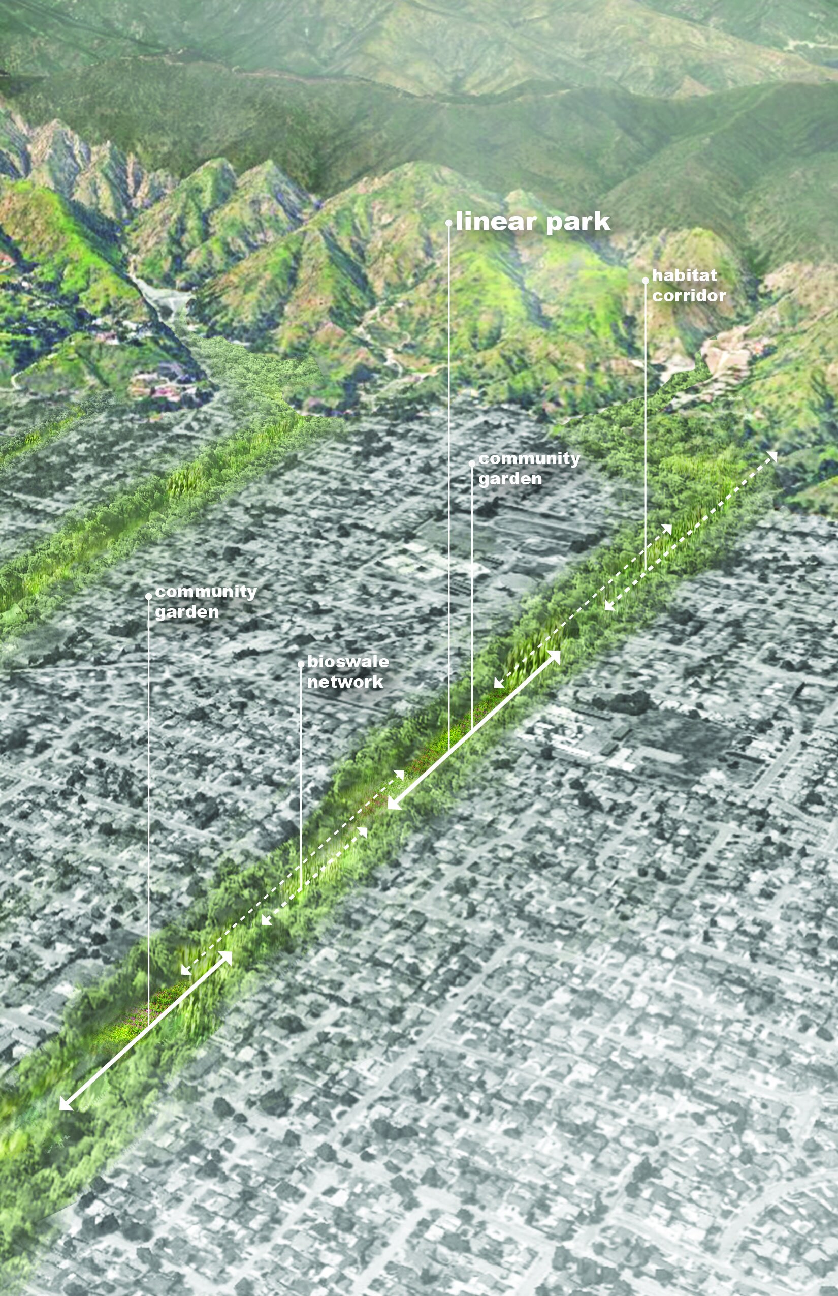
Debris-sheds
We typically understand mountainous terrain in terms of watersheds. Federal Emergency Management Agency (FEMA) stormwater models abound, forecasting 100-year and 200-year flood risk. However, these models do not (and cannot) account for the risk of mud or debris. Not unlike the idea of a watershed, the term “debris-shed” is coined to conceptualize the path and establish patterns of development around alluvial fans and hazard areas caused by debris flow. Formulating the idea of “debris-sheds” accounts for these conditions and creates new criteria for development in the wildland-urban interface by establishing zones of risk tied to development patterns. Currently, development creeps onto alluvial fans without regard to the fact that they are located at the mouth of ravines and channels that funnel debris during an event. This new form of zoning acknowledges these hidden forces through an understanding of the relationship between the mountains and the sea. Mountains, in the shedding of its material, replenish sediment at beaches and riverbanks. By reopening these corridors to allow for the flow of material, we can create a multiple linear debris “parks,” which can serve to mitigate the effect of debris flows in neighborhoods at risk of mudslides during the seasonal fire-then-flood event cycles, while providing large open park space in ordinary times. The city, then, becomes a vast networks of linear parks and habitat corridors, connecting the “flats” of the city with the terrain of the Santa Monica and San Gabriel Mountains, realizing the 1930 Olmsted-Bartholomew plan for Los Angeles, replete with recreational open spaces, that serve as overflow spaces during floods, connected to vital ravines and watersheds throughout the region.